I read this today and couldn’t believe it was true until I looked at a map.
What other fun geography tidbits do you know?
Hello and thank you for being a DL contributor. We are changing the login scheme for contributors for simpler login and to better support using multiple devices. Please click here to update your account with a username and password.
Hello. Some features on this site require registration. Please click here to register for free.
Hello and thank you for registering. Please complete the process by verifying your email address. If you can't find the email you can resend it here.
Hello. Some features on this site require a subscription. Please click here to get full access and no ads for $1.99 or less per month.
I read this today and couldn’t believe it was true until I looked at a map.
What other fun geography tidbits do you know?
| by Anonymous | reply 157 | September 9, 2018 5:45 AM |
There is a small section of the United States entirely surrounded by Canada - you cannot get to the states without driving through Canada first. And no, it is not Alaska.
| by Anonymous | reply 1 | August 6, 2018 4:29 AM |
There are towns in Texas closer to Chicago than the southern border with Mexico.
| by Anonymous | reply 2 | August 6, 2018 4:31 AM |
R1 Is it Florida in the winter?
| by Anonymous | reply 3 | August 6, 2018 4:32 AM |
Are you in fourth grade, OP?
| by Anonymous | reply 4 | August 6, 2018 4:32 AM |
Istanbul is in two continents.
| by Anonymous | reply 5 | August 6, 2018 4:36 AM |
St. John's, Newfoundland and Labrador is closer to Dublin, Ireland and Suriname than it is to Victoria, British Columbia.
St. John's, Newfoundland and Labrador is roughly on the same latitude as Seattle, Washington.
| by Anonymous | reply 6 | August 6, 2018 4:40 AM |
r1 here are the other seven places besides Alaska
| by Anonymous | reply 7 | August 6, 2018 4:40 AM |
Norway has longer coastline than the entire USA does.
| by Anonymous | reply 8 | August 6, 2018 4:41 AM |
The Panama Canal runs North/South, not East/West.
| by Anonymous | reply 9 | August 6, 2018 4:42 AM |
Cincinnati, OH Airport is in Kentucky.
| by Anonymous | reply 10 | August 6, 2018 4:42 AM |
Windsor is south of Detroit.
| by Anonymous | reply 11 | August 6, 2018 4:44 AM |
I can see Russia from my house!
| by Anonymous | reply 12 | August 6, 2018 4:45 AM |
R1 - stinky linky. I was talking about Port Roberts, WA.
| by Anonymous | reply 13 | August 6, 2018 4:45 AM |
Point Roberts, WA. I crossed the border at Tsawwassen to get some gas. Cheeky border agents! "Did you buy any firearms?" "Of course not! I was there for ten minutes! Why'd you ask?" "Because you could."
| by Anonymous | reply 14 | August 6, 2018 4:48 AM |
I know that NOW, wiseass at R11
| by Anonymous | reply 15 | August 6, 2018 4:50 AM |
You can travel via water from the Atlantic ocean all the way to Minnesota!
| by Anonymous | reply 16 | August 6, 2018 4:52 AM |
It’s only 90 miles to Cuba from key west Florida
| by Anonymous | reply 17 | August 6, 2018 4:53 AM |
Reno NV is further west than Los Angeles CA
| by Anonymous | reply 18 | August 6, 2018 4:56 AM |
Portland, Oregon is farther north than Portland, Maine.
| by Anonymous | reply 19 | August 6, 2018 4:57 AM |
Maine, while sometimes appearing to be the northernmost of the 48 contiguous states, actually ranks sixth after Washington, Idaho, Montana, North Dakota, and Minnesota.
| by Anonymous | reply 20 | August 6, 2018 5:01 AM |
Oh shit. Now there’s a fun fact troll sloshing in the mud.
| by Anonymous | reply 21 | August 6, 2018 5:03 AM |
With about 41 miles separating them, Boston MA and Providence RI are the closest state capitols in the US.
| by Anonymous | reply 22 | August 6, 2018 5:05 AM |
capitals*
| by Anonymous | reply 23 | August 6, 2018 5:05 AM |
The most populous county in the US (Los Angeles) is adjacent to the largest county in the US (San Bernardino.)
| by Anonymous | reply 24 | August 6, 2018 5:14 AM |
Boston is closer to Lisbon than to Anchorage.
| by Anonymous | reply 25 | August 6, 2018 5:24 AM |
New York is *almost* closer to London (3,459 miles) than the shortest all-interstate route between Miami and Seattle (3,300 miles).
As a practical matter, it's usually FASTER to fly between New York & London than it is to fly between Miami and Seattle (at least, when flying in the same direction as the jet stream)... NY-LON, you can fly with the jet stream almost the entire way AND the plane isn't going to stop somewhere between the two. In contrast, there are few nonstop flights between Miami and Seattle, and THOSE rarely involve the jet stream for more than a third of the flight.
| by Anonymous | reply 26 | August 6, 2018 5:38 AM |
When measured from east to west, Hawaii is the second widest state in the United States, after Alaska. Hawaii is the most southern US state, just a few degrees south of the Tropic of Cancer. Hawaii is on the same latitude as Mexico City and Mecca.
| by Anonymous | reply 27 | August 6, 2018 5:50 AM |
That's the case for almost all east-to-west flights, correct R26? I remember I read somewhere that there is more turbulence on westbound flights than eastbound flights because you're dealing with headwinds.
I love this thread. More!
| by Anonymous | reply 28 | August 6, 2018 5:54 AM |
China is the third largest country by area and only has one observed time zone. When you cross the border to Afghanistan, there is a 3.5 hour time difference.
| by Anonymous | reply 29 | August 6, 2018 5:57 AM |
Correction: China is the fourth largest country by area. The US is third.
| by Anonymous | reply 30 | August 6, 2018 5:58 AM |
Vancouver is south of London in latitude. Denver is south of Rome.
The driving distance between London and Edinburgh is roughly the same distance between Chicago and Minneapolis.
| by Anonymous | reply 31 | August 6, 2018 6:00 AM |
Honolulu is 2,479 miles from Los Angeles by air, while New York City is only 2,446 miles from Los Angeles by air.
| by Anonymous | reply 32 | August 6, 2018 6:08 AM |
Pelee Island, Ontario, Canada is farther south than . . .
Yreka, California, United States and . . .
Rome, Italy
| by Anonymous | reply 33 | August 6, 2018 6:09 AM |
R29, yeah, but there are a few good reasons:
1. The OVERWHELMING majority of China's population lives in eastern China. Specifically, if you took an area as wide as the westernmost longitude of Central Time to the easternmost longitude of Eastern Time and applied it to China (with the eastern longitude aligned with China's easternmost longitude), something like 95% of its population would fall within it.
2. Continuing with the Central-Eastern example, the halfway point is about as sprawling, urban, and messy as the border between Ohio and Indiana. Simply put, there IS NO PLACE near the middle of a zone over China the width of Central+Eastern time where you could draw a dividing line without hardship & major inconvenience to several MILLION people.
Factoid: Indiana's past DST wackiness had NOTHING to do with "farmers", and EVERYTHING to do with messy urban areas that straddled the timezone line where people lived on one side, but worked on the other. By remaining on standard time year-round, it put them in the same de-facto timezone as their neighboring town on the other side for 6-8 months/year.
| by Anonymous | reply 34 | August 6, 2018 6:15 AM |
R34 - actually those few wacky areas put them on the same time zone for the entire year - e.g. NW Indiana.
| by Anonymous | reply 35 | August 6, 2018 6:22 AM |
Boring
| by Anonymous | reply 36 | August 6, 2018 6:25 AM |
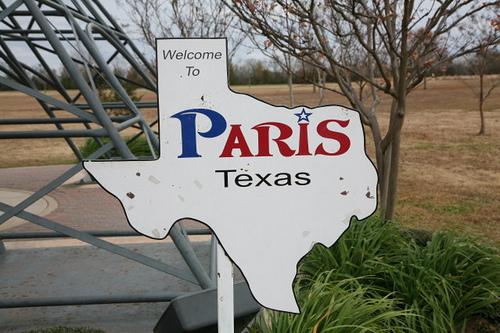
Houston and Dallas are both in Texas but Paris is in France!
Toronto is the 4th largest city in North America.
Montreal has two official languages but you can only speak one.
Pittsburgh is pretty in person.
San Francisco is 49 square miles surrounded by reality.
| by Anonymous | reply 37 | August 6, 2018 6:34 AM |
Well, Paris is in Texas, too.
| by Anonymous | reply 38 | August 6, 2018 6:40 AM |
Paris is in France moron.
| by Anonymous | reply 39 | August 6, 2018 7:22 AM |
The Atlantic end of the Panama Canal is further west than the Pacific end.
| by Anonymous | reply 40 | August 6, 2018 7:29 AM |
Paris is in France.
| by Anonymous | reply 42 | August 6, 2018 7:38 AM |
Paris is in Ontario.
| by Anonymous | reply 43 | August 6, 2018 7:44 AM |
Paris is in Ontario and also in France. But never in Texas.
| by Anonymous | reply 44 | August 6, 2018 7:46 AM |
r34 True - but it's still weird that the sun rises in Xinjiang province at 10 am in January and sets at 9 pm, whereas in Eastern China it rises at 7 and sets at 6 pm at that time of year at the same latitude. (This western China time would be great for me, as a night owl, but disaster for a school student who would have to be in school every morning for 3 hours before the sun would even be rising).
| by Anonymous | reply 45 | August 6, 2018 7:47 AM |
[quote] San Francisco is 49 square miles surrounded by reality.
San Francisco is 49 square miles covered in shit!
| by Anonymous | reply 46 | August 6, 2018 8:02 AM |
One in three Americans killed by strangers is killed by the police.
| by Anonymous | reply 47 | August 6, 2018 8:04 AM |
On the Mercator map, Russia is so huge, it dwarfs the continent of Africa. In reality, Africa is 1.77 times as big as Russia.
Similarly, Greenland looks to be about the same size as Africa, but, in reality, Africa is 14 times larger.
| by Anonymous | reply 48 | August 6, 2018 11:46 AM |
There are parts of Mexico that are closer to Atlanta than Los Angeles.
| by Anonymous | reply 49 | August 6, 2018 12:01 PM |
Houston is slightly farther south than Cairo.
| by Anonymous | reply 50 | August 6, 2018 12:03 PM |
Jacksonville, Florida is the largest city in the United States. By square mile, not population.
| by Anonymous | reply 51 | August 6, 2018 1:12 PM |
[quote]I was talking about Port Roberts, WA.
There's also Minnesota's Northwest Angle.
| by Anonymous | reply 52 | August 6, 2018 2:16 PM |
At its widest point, the Pacific Ocean covers more than 180 degrees of latitude (more than half the planet).
| by Anonymous | reply 53 | August 6, 2018 2:32 PM |
The lowest and highest points in the continental US (the “lower 48”) are only 80 miles away from each other.
| by Anonymous | reply 54 | August 6, 2018 2:35 PM |
The Great Lakes contain 21% of the planet's fresh water and here's a bonus visual for R49
| by Anonymous | reply 55 | August 6, 2018 2:41 PM |
During the Northern Hemisphere winter, the time difference between California and the New Zealand Time Zone is only 3 hours (plus a day) - so in practical terms it’s the same as the difference between Pacific and Eastern time.
| by Anonymous | reply 56 | August 6, 2018 2:54 PM |
Unless it's a vast right wing conspiracy: I give you Paris TEXAS
| by Anonymous | reply 57 | August 6, 2018 3:00 PM |
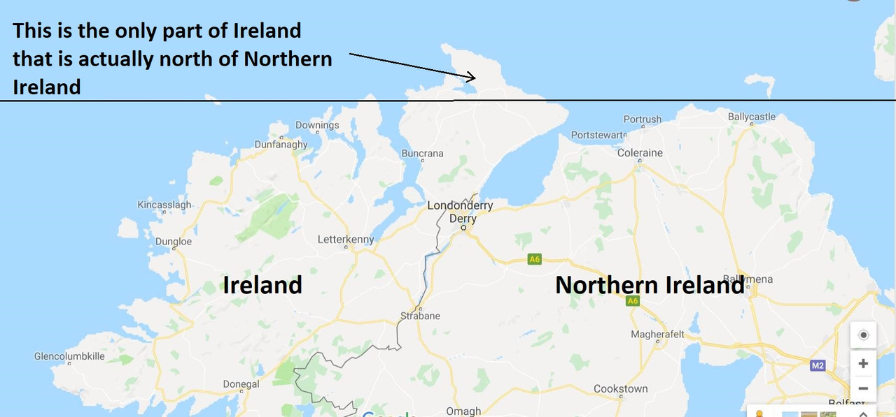
Southern Ireland is actually above Northern Ireland.
| by Anonymous | reply 58 | August 6, 2018 3:02 PM |
Southern Ireland is actually above Northern Ireland.
| by Anonymous | reply 59 | August 6, 2018 3:02 PM |
Part of Kazakhstan is in Europe.
| by Anonymous | reply 60 | August 6, 2018 3:08 PM |
The land under the Captain Cook Memorial at Kealakakua Bay, Hawaii is owned by Britain.
| by Anonymous | reply 61 | August 6, 2018 3:20 PM |
All of Maryland’s lakes are man made.
| by Anonymous | reply 62 | August 6, 2018 4:46 PM |
[quote]I was talking about Port Roberts, WA.
It's POINT Roberts.
| by Anonymous | reply 63 | August 6, 2018 4:54 PM |
[quote] Boring
... is a city in Oregon. Its sister city is DULL, Scotland.
| by Anonymous | reply 64 | August 6, 2018 4:55 PM |
An 18th century charter owned by the Duke of Monmouth states that the US colonies can be returned to Britain should he so wish it.
| by Anonymous | reply 65 | August 6, 2018 5:02 PM |
The whole-number latitude of every permanent human settlement having a commercial cell phone tower can be encoded as a 7-bit offset north of 53 degrees south (Antarctica has cell towers, but none are commercial... McMurdo's tower is operated by Raytheon for employees & visitors, but is basically run like a private cell phone service on a cruise ship or plane).
| by Anonymous | reply 66 | August 6, 2018 5:14 PM |
It’s possible to travel for 19,940 miles in a straight line without hitting land.
| by Anonymous | reply 68 | August 6, 2018 6:28 PM |
Uranus is an insatiable bottom, just like the World Trade Center Sr.
| by Anonymous | reply 69 | August 6, 2018 6:30 PM |
I visited Fort Galle on the south coast of Sri Lanka. My guide told me that if I went due south the next landfall would be Antarctica. Considering that Sri Lanka is above the Equator in the Northern Hemisphere I thought that was very interesting.
| by Anonymous | reply 70 | August 6, 2018 6:39 PM |
The same is true if you head due south from certain spots in the western Aleutians - the next landfall would be in Antarctica, 9000 miles away.
| by Anonymous | reply 71 | August 6, 2018 6:56 PM |
The total distance from the northern tip to the southern tip of Japan is equivalent to the distance between Florida and Newfoundland.
| by Anonymous | reply 72 | August 6, 2018 6:58 PM |
Virginia goes further west than West Virginia.
| by Anonymous | reply 73 | August 6, 2018 7:12 PM |
I'm internationally beloved porn star Brent Everett and I am here to tell you that Paris is in FRANCE. Check out my jerking off under the Eyeful Tower video at BrentEverett.com.
| by Anonymous | reply 74 | August 6, 2018 8:27 PM |
Bump
| by Anonymous | reply 75 | August 7, 2018 12:02 AM |
Krakatoa lies east of Java.
| by Anonymous | reply 76 | August 7, 2018 12:03 AM |
Fun fact: Krakatoa is actually *west* of Java.
| by Anonymous | reply 77 | August 7, 2018 12:05 AM |
Walking from Salzburg to Switzerland involves only a light stroll, that's suitable even for small kids.
| by Anonymous | reply 78 | August 7, 2018 12:24 AM |
| by Anonymous | reply 79 | August 7, 2018 12:55 AM |
Brazil and France share a border.
| by Anonymous | reply 80 | August 7, 2018 1:11 AM |
Maine is closer to Africa than Florida is.
| by Anonymous | reply 81 | August 7, 2018 1:18 AM |
That's a stretch R80.
| by Anonymous | reply 82 | August 7, 2018 1:21 AM |
A small Island off the coast of Newfoundland is part of France, actually it's sort of its own country...but, the citizens all come into Newfoundland Canada for their shopping.
| by Anonymous | reply 83 | August 7, 2018 1:26 AM |
Only 2 European capitals are south of Washington, DC.
| by Anonymous | reply 84 | August 7, 2018 1:28 AM |
In Florida, the more North you go, the more South it gets.
| by Anonymous | reply 85 | August 7, 2018 1:31 AM |
27 US states are at least partly north of the most southern part of Canada.
| by Anonymous | reply 86 | August 7, 2018 1:35 AM |
Brussels is a French-speaking enclave within the Dutch-speaking part of Belgium.
| by Anonymous | reply 87 | August 7, 2018 2:00 AM |
R23 it IS "capitols".
| by Anonymous | reply 88 | August 7, 2018 2:04 AM |
Part of Egypt is in Asia.
| by Anonymous | reply 89 | August 7, 2018 2:10 AM |
Egypt is known as Masr to Egyptians themselves.
| by Anonymous | reply 90 | August 7, 2018 2:11 AM |
no, r88
With about 41 miles separating them, the Massachusetts State House and the Rhode Island State House are the closest state capitols in the US.
but
With about 41 miles separating them, Boston MA and Providence RI are the closest state capitals in the US.
| by Anonymous | reply 91 | August 7, 2018 2:18 AM |
R82, French Guyana is as French as Alaska is American. In fact Cayenne is closer to its national capital than Juneau is.
| by Anonymous | reply 92 | August 7, 2018 2:21 AM |
Oops! It turns out that Alaska is closer to DC than Cayenne is to Metropolitan France. But only by 1000 miles or so.
| by Anonymous | reply 93 | August 7, 2018 2:26 AM |
Correct r83...St. Pierre and Miquelon...
| by Anonymous | reply 94 | August 7, 2018 2:31 AM |
R53, and that means that, if you were able to dig a hole straight through the earth and wind up on the other side, there are parts of the Pacific where you could do that and wind up in the Pacific again.
| by Anonymous | reply 95 | August 7, 2018 2:58 AM |
The US has more land area than Canada. Canada only claims to be larger because they count water.
37% of the US is north of Toronto, but only 7% of the people live there.
| by Anonymous | reply 96 | August 7, 2018 4:34 AM |
Canada has the largest amount of coastline of any country on earth,10 times more than the US.
| by Anonymous | reply 97 | August 7, 2018 5:03 AM |
Damn you, R81. I was scrolling through all of these so that I could share that one! You beat me!
| by Anonymous | reply 98 | August 7, 2018 7:02 AM |
You can fit the entire landmass of the US, China, India, Japan, and all of Europe into Africa and have space left over.
| by Anonymous | reply 99 | August 7, 2018 11:26 AM |
Edinburgh, Scotland is further north than Moscow, Russia.
| by Anonymous | reply 100 | August 7, 2018 11:36 AM |
Africa by Weezer is not as great as Africa by Toto.
| by Anonymous | reply 101 | August 7, 2018 11:40 AM |
There is a white guy with a thick 11 inch cock who cruises the Danube Island.
| by Anonymous | reply 102 | August 7, 2018 12:15 PM |
The total land area of Japan is 377,915 square kilometres. Montana is 380,832 sq. km.
| by Anonymous | reply 103 | August 7, 2018 12:52 PM |
One in three Canadians live in the province of Ontario and half of those live in the Greater Toronto Area.
| by Anonymous | reply 104 | August 7, 2018 12:58 PM |
[quote]Correction: China is the fourth largest country by area. The US is third.
China is a larger landmass than America (people don't realize how big that country is), but yes America takes the lead when you count the associated water bodies.
| by Anonymous | reply 105 | August 7, 2018 12:58 PM |
R83 fun fact: St. Pierre and Miquelon send a senator and a deputy to the National Assembly in Paris.
A friend of mine once spent a few weeks there on a French immersion course.
| by Anonymous | reply 106 | August 7, 2018 12:58 PM |
Australia is roughly the same size as the continental US, but it's population is roughly the same as the NY combined metro region.
It's population density is about 8.8 people per square mile.
| by Anonymous | reply 107 | August 7, 2018 1:02 PM |
85% of Aussies live within 50 km of the coast.
| by Anonymous | reply 108 | August 7, 2018 1:05 PM |
I once read about 10 years ago that if the entire human population of Earth stood shoulder to shoulder they would fit into Prince Edward Island - Canada's smallest province. It may not be the case now.
| by Anonymous | reply 109 | August 7, 2018 1:20 PM |
[quote]Walking from Salzburg to Switzerland involves only a light stroll, that's suitable even for small kids.
Don’t you mean Salzburg to Germany? Switzerland is about a 4-hour drive.
| by Anonymous | reply 110 | August 7, 2018 4:39 PM |
Texas could house the entire population of the earth if you divided it into 50x100 foot lots with single-family homes at typical American-suburbia density (though things like transportation would be impossible... too dense for roads capable of handling the traffic from 4 billion people, but not dense enough for subways to be viable. Not to mention things like offices, stores, schools, utilities, etc).
| by Anonymous | reply 111 | August 7, 2018 4:50 PM |
Bangladesh is a country few people think about that is only the size of Iowa...but has a population of 163 million, it is the 8th most populous country on earth.
| by Anonymous | reply 112 | August 7, 2018 4:57 PM |
R110 has apparently never seen "The Sound of Music."
| by Anonymous | reply 113 | August 7, 2018 5:31 PM |
California has 12% of the US population. Therefore, roughly one out of every eight or nine Americans lives in California.
| by Anonymous | reply 114 | August 7, 2018 5:33 PM |
[quote]roughly one out of every eight or nine Americans lives in California.
Which makes for a very unfair electoral system that gives too big a voice to empty states instead of representing legitimately what most Americans want.
| by Anonymous | reply 115 | August 7, 2018 5:37 PM |
^ Similarly, the population of NYC is greater than the combined population of Idaho, Montana, Wyoming, North Dakota, South Dakota and Nebraska.
| by Anonymous | reply 116 | August 7, 2018 5:50 PM |
We'd just like to say "Howdy!" to y'all folks in this thread claimin' there ain't no Paris in Texas!
| by Anonymous | reply 117 | August 9, 2018 10:59 PM |
Rhode Island is neither a road nor an island. Discuss.
| by Anonymous | reply 118 | August 9, 2018 11:14 PM |
What is the only -stan country that's surrounded by other -stan countries? Uzbekistan. It's bordered by Turkmenistan, Afghanistan, Tajikistan, and Kazakhstan.
| by Anonymous | reply 119 | August 9, 2018 11:15 PM |
I would like to be surrounded by Sebastian Stan.
| by Anonymous | reply 120 | August 9, 2018 11:36 PM |
The capital of Wyoming is, like, W
| by Anonymous | reply 121 | August 9, 2018 11:37 PM |
Apparently Pakistan is a meaningless name. Paki doesn't really refer to a tribal group or language or region. It's origin is shrouded in obscurity.
| by Anonymous | reply 122 | August 10, 2018 9:40 PM |
[quote]Rhode Island is neither a road nor an island. Discuss.
Not much to discuss. Aquidneck was called Rhode Island by early settlers. It's still the official government name of the island. We just call it by its original Narragansett name now.
| by Anonymous | reply 123 | August 11, 2018 7:03 PM |
R122, Pakistan comes from PAKSTAN, a coinage derived from the five northern provinces of the British Raj: Punjab, Afghania, Kashmir, Sindh, and BaluchisTAN.
| by Anonymous | reply 124 | August 11, 2018 9:22 PM |
There's also a paris in California. (spelled Perris)
| by Anonymous | reply 125 | August 24, 2018 7:07 AM |
Perth in Western Australia is closer to Singapore than Sydney, New South Wales.
| by Anonymous | reply 126 | August 24, 2018 7:23 AM |
You amuse me, R121. Thanks for the laugh.
| by Anonymous | reply 127 | August 24, 2018 8:13 AM |
r119 You forgot Kyrgyzstan, which also borders Uzbekistan.
| by Anonymous | reply 128 | August 24, 2018 8:17 AM |
There are really only two continents: America and Eurasia/Africa. Australia is too small and Antarctica too cold.
| by Anonymous | reply 129 | August 24, 2018 9:11 AM |
Hawaii is the southernmost U.S. state. Alaska is the most northern, western, AND eastern state. A few of the Aleutian Islands lie across the international date line.
| by Anonymous | reply 130 | August 24, 2018 9:45 AM |
I personally believe that U.S. Americans are unable to do so because, uh, some people out there in our nation don't have maps and, uh, I believe that our education, like such as in South Africa and, uh, the Iraq, everywhere like such as, and I believe that they should—our education over here in the U.S. should help the U.S., uh, or, should help South Africa and should help the Iraq, and the Asian countries, so we will be able to build up our future, for our children.
| by Anonymous | reply 131 | August 24, 2018 11:13 PM |
Washington DC is the capitol of the US, and is named after George Washington, the first president of the US.
There is another county whose capitol is named after a US president. Do you know which one? Not a trick question.
| by Anonymous | reply 132 | August 25, 2018 12:09 AM |
r132 Monrovia, Liberia. But I should've refused to answer your question because you don't know the difference between "capitol" and "capital."
| by Anonymous | reply 133 | August 25, 2018 12:18 AM |
Well I'll be dipped in shit.
| by Anonymous | reply 134 | August 25, 2018 12:21 AM |
[quote]Reno NV is further west than Los Angeles CA.
No matter how many times I've read or heard this, it always boggles my mind because, being a Californian, I think of everything in Nevada as eastward.
| by Anonymous | reply 135 | August 25, 2018 12:32 AM |
No it isn’t, r126. Perth is 411 miles closer to Sydney than to Singapore..
| by Anonymous | reply 136 | August 28, 2018 10:26 PM |
There are four US capitals named after presidents.
| by Anonymous | reply 137 | August 28, 2018 10:46 PM |
If you meant country, not county then it would be Monrovia
| by Anonymous | reply 138 | August 28, 2018 10:48 PM |
r138, see r133
| by Anonymous | reply 139 | August 28, 2018 10:49 PM |
[quote]There are four US capitals named after presidents.
Lincoln, Jefferson City, Jackson, Madison
| by Anonymous | reply 140 | August 28, 2018 10:53 PM |
If all Trump supporters stood shoulder to shoulder, would they fit into the Mariana Trench? Let's try it and see...
| by Anonymous | reply 141 | August 28, 2018 11:15 PM |
Elephants are afraid of bees.
| by Anonymous | reply 142 | September 7, 2018 2:12 PM |
The richest county in New England is the furthest south and west (Fairfield County, CT.) The poorest county in New England is the furthest east, (Washington County, ME.)
| by Anonymous | reply 143 | September 7, 2018 2:54 PM |
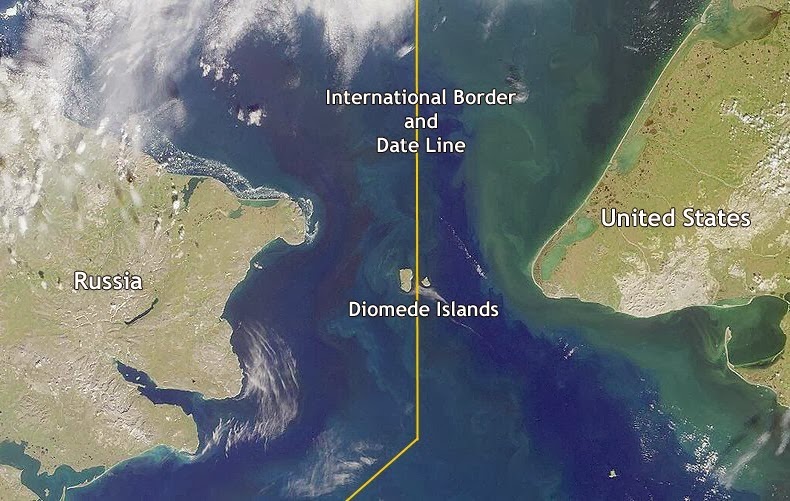
Only 2.4 miles separate the Bering Strait islands of Big Diomede (Russia) from Little Diomede (USA), however, because the International Date Late runs between the two, Big Diomede is 21 hours ahead of Little Diomede. Hence, their respective nicknames "Tomorrow Island" and "Yesterday Isle."
During the winter months, an ice bridge sometimes connects the two islands, thus making it technically possible to walk from the US to Russia. However, it is illegal to do so. Little Diomede inhabitants who've strayed too close to Big Diomede have gotten arrested and detained by Russian border guards.
| by Anonymous | reply 144 | September 7, 2018 6:05 PM |
Thank you, R144, that's the kind of peculiar little fact that makes this thread fun!
| by Anonymous | reply 145 | September 7, 2018 9:09 PM |
Almost the entire landmass of South America lies to the east of the same meridian that runs through Miami, Florida.
| by Anonymous | reply 146 | September 8, 2018 7:32 AM |
The country with the most borders is the Republic of China - it shares its international borders with 14 sovereign states and 2 special territories.
| by Anonymous | reply 147 | September 8, 2018 7:36 AM |
Zimbabwe has the highest number of official languages in the world. Zimbabwe's constitution has provision for 16 official languages which are Chewa, Chibarwe, English, Kalanga, Koisan, Nambya, Ndau, Ndebele, Shangani, Shona, Sotho, Tonga, Tswana, Venda, Xhosa, and sign language.
| by Anonymous | reply 148 | September 8, 2018 7:38 AM |
Big and Little Diomedes had roles in one of the Tales of the City books.
| by Anonymous | reply 149 | September 8, 2018 10:53 AM |
New Jersey is the only "New" state (as compared with NY, NM, NH) where the residents pretty much discard the "New"
| by Anonymous | reply 150 | September 8, 2018 1:29 PM |
[quote] Southern Ireland is actually above Northern Ireland.
There is no such thing as "southern Ireland". There is a very small area of Ireland that is slightly above Northern Ireland.
| by Anonymous | reply 151 | September 8, 2018 1:56 PM |
I knew that when I was five. Are you a five year old OP?
I would think by the time you are old enough to post on the Internet, say eight, you'd know things like this.
| by Anonymous | reply 152 | September 8, 2018 3:53 PM |
I'd say "Fuck YOU", R152, if I wasn't absolutely sure you haven't been fucked in decades.
| by Anonymous | reply 153 | September 9, 2018 1:20 AM |
[quote] — Frau Schmidt, preparing pink lemonade as I type
Not too tart, not too sweet!
| by Anonymous | reply 154 | September 9, 2018 1:24 AM |
El Paso Texas is closer to the California border than it is to Houston Texas
| by Anonymous | reply 155 | September 9, 2018 1:49 AM |
Pensacola (FL) is closer to Houston (TX) than Miami (all distances via most direct limited-access highway route).
Driving to Miami from Texas & seeing just *how far* Pensacola is from *everything* (INCLUDING Tallahassee) makes you appreciate just how huge Florida, Texas, and California really are (and by extension, comparably-large countries like Britain, France, Germany, Spain, Poland, Sweden, etc).
| by Anonymous | reply 156 | September 9, 2018 5:25 AM |
Lady Gaga was born in NYC and she actually won a Golden Globe for her acting.
| by Anonymous | reply 157 | September 9, 2018 5:45 AM |
Yes indeed, we too use "cookies." Take a look at our privacy/terms or if you just want to see the damn site without all this bureaucratic nonsense, click ACCEPT. Otherwise, you'll just have to find some other site for your pointless bitchery needs.
Become a contributor - post when you want with no ads!